A useful way to study this part of the battle is to look at different maps from various eras, starting with Ferraris and moving to the 20th Century.
First of all some comparisons of the wider area of Smohain:
 |
| Ferraris Map |
 |
| A second version of the Ferraris map (the first being Flemish, the second Walloon). |
 |
| 1846 map |
 |
| 1873 |
 |
| 1939 |
 |
| 1971 aerial photograph after Frischermont was destroyed. |
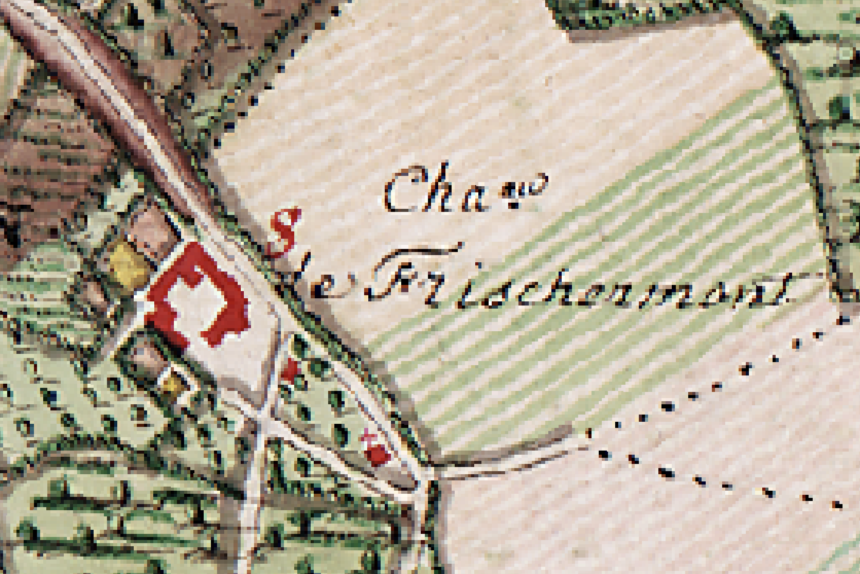
And then the detail around Frischermont:
 |
| Ferraris Walloon, showing a chapel or shrine |
 |
| Ferraris Flanders |
 |
| Cadastral map 1840 - this is the most useful. The out building at 35 is noted; is it the chapel? |
 |
| 1846 |
 |
| 1873. The tower has gone and the more modern mansion has been built |
 |
| 1904. The blue circle must be the well. |
 | | 1939 |
 |
| 1971 |


Impressive detective work being done here. The quality of those old maps is extraordinary - individual trees!
ReplyDeleteVery interesting. I was wondering if there were any WW2 aerial photos available which show the buildings. There don’t seem to be any available at NCAP but that may be me searching badly. I had a look at another site but again, nothing. It may just be that this area (fortunately). avoided any action so wasn’t of much interest.
ReplyDeleteThat's a great idea which I hadn't thought of. If you find any, I'd be interested
ReplyDeleteI found a better search method on NCAP but sadly nothing for the Frischermont area. It may be that there are pictures but they haven’t been digitised so will need an annual subscription and site visit.
ReplyDeleteUnderstood, many thanks for looking
ReplyDeleteSuper, what about the 1817 maps
ReplyDeleteI've just discovered your blog and I'm truly amazed by your work and that of your team, not to mention your father, whose buildings are truly magnificent.
ReplyDeleteThe whole thing is impressive, and I wouldn't be surprised to learn that it will one day find its place in the National Army Museum.
I would like to make three comments:
- The first concerns French generals.
Under the First Empire, there were two ranks and three functions.
The two ranks were Brigadier General and Divisional General, which would become Field Marshal and Lieutenant General, respectively, after the first Restoration in 1814. Napoleon did not revert to these titles in 1815, as the rank of Lieutenant General was more honorary than Divisional General.
The three functions were Brigade Commander, Division Commander, and General-in-Chief. A Divisional General (Lieutenant General) therefore commanded an army corps. To distinguish himself from the other Divisional Generals whose uniform he wore, he wore a bicorn hat with white plumes. Brigadier and Divisional Generals wore black plumes. (Regulation of 1 Vendémiaire, Year XII).
As always with the French, there was one exception. It concerned Prince Jérôme Bonaparte, brother of the Emperor and short-lived King of Westphalia. During the Russian campaign, he commanded the Right Army Group and acted as general-in-chief. At Waterloo, he commanded the 6th Division of the 2nd Corps, but having commanded in chief in Russia, he retained his white plumes.
Naturally, field marshals command in chief and wear white plumes
- The second observation concerns the flags of the regiments of the Kingdom of Holland. They were not distributed until after the Belgian campaign and were not present at Waterloo. Only certain regiments of the Principality of Orange-Nassau had yellow flags bearing a golden rampant lion in their center on a blue circle surrounded by two green laurel branches.
- The third observation concerns the 23rd Regiment of Foot (Royal Welch Fusiliers). The fusilier regiments (7th, 21st, and 23rd) were the first regiments armed with a rifle, hence their name fusiliers. At that time, the other infantry regiments were armed with a musket or arquebus. The fusiliers' mission at their creation was to defend artillery pieces. They could not move among the powder crates with a lit fuse. This is why they were the first to receive rifles. The mission of defending the cannons being of high importance they were considered elite and all companies wore the wings including the central companies.
I could blame you for such a mistake, but I made the same one a few years ago.
For uniforms, ranks, and flags, I recommend the following website:
http://centjours.mont-saint-jean.com/detail_uniformes_chefFR.php?nom=&rubrique=C&uniformes=1
http://centjours.mont-saint-jean.com/detail_uniformes_uniteBR.php?nom=1er%20Bataillon%20du%201er%20R%C3%A9giment%20Duc%20de%20Nassau&rubrique=U&uniformes=44&nation=4
http://centjours.mont-saint-jean.com/detail_uniformes_uniteBR.php?nom=I/23rd%20Regiment%20of%20Foot&rubrique=U&uniformes=104&nation=1
Dear Blue Willow, I don't know the 1817 maps, but would love to look at them. Can you send me a link?
ReplyDeleteDear French Follower, many thanks for your comments. I am familiar with French ranks having been a serving soldier myself. I think I am right in saying that by the 19th Century Fusilier regiments were armed with the India Pattern musket and not the Baker rifle. Thank you for those links which I use a lot and I fully agree are very helpful. Thanks for the thoughts on Dutch flags - you are of course right.